Goole
Firstly thank you to Dave Scouts and Kevin Too for suggesting Bingmaps. The National Library of Scotland map images alongside the satellite image is very interesting. I’ve sneakily put an extract here that shows the railway line. We’ve come across this before but had forgotten about it. Have to say though these maps make it very easy to see where an old railway used to be, I quite like trying to work it out for myself from the satellite images, but can then confirm my suspicions using this and OS maps.

The actual bank slip along this stretch is about 400ft east of where the railway bridge was. Paul (Waterway Routes) pointed this out from examining my photos, Marks photos and the flag on a map I’d put up the other day. Mick had also spotted this when we’d first seen the comment on Facebook. All interesting stuff to keep you busy on a winter Sunday afternoon.

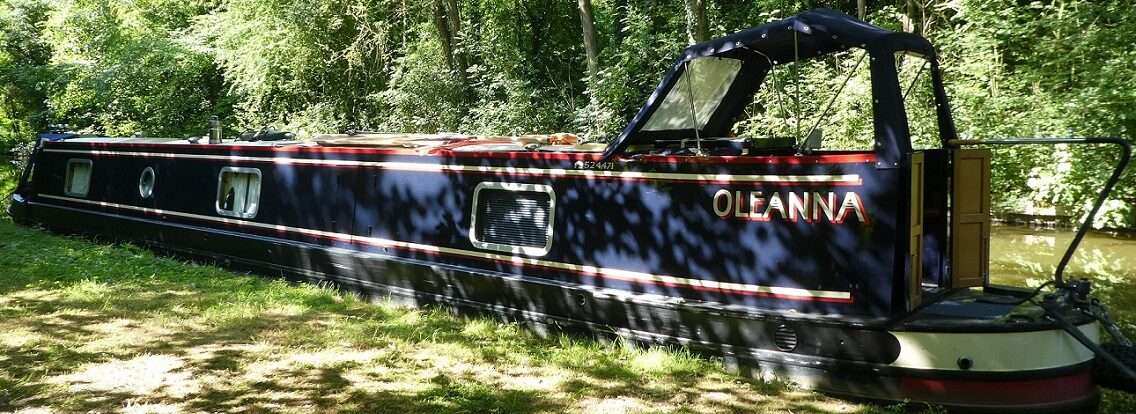
Today we kept ourselves busy too. The hire car keys will be handed back tomorrow so one last trip to check on Oleanna before it gets a little bit harder to do so, or impossible when a new lockdown is imposed. So after breakfast we hopped in the car to cross the Wolds and wish Oleanna a Happy New Year.

Stepping down onto the stern was a touch easier again. Measurements were taken 34 inches to the top of the pontoon from the water level, this started off at 48 inches, when I first thought of measuring it. Up some more, which is good news despite the breach leaking and some ships coming and going from the port again.


Today I remembered to take the freshly washed blinds for the front door back. Measurements were taken as I’ve not made new ones yet and one of the poppers which has needed replacing for a while definitely needs attention before we sleep on board again.


But I’ll need a die set and spare poppers to do this, hopefully someone in Scarborough might be able to lend me the die set. My next problem will be what size the poppers are, 10mm, 12mm, 11mm heavy duty. I measured everything except the flipping popper size!
Porthole bungs were put back in their covers and hung back on doors, ready to be deployed on those Spring mornings when the sun beats in through the bathroom windows long before anyone wants to be awake.
Mick turned Oleanna’s key and started her up. She was a little bit surprised at being woken up from her long sleep, but soon relished her engine whirring, warming up the engine bay.

Over our packed lunch we had the same discussion as before, whether to tighten the ropes or not. The marina is quite frozen at the moment, certainly between us and our nearest neighbours. Down the side of Oleanna there was a gap, she’s obviously been moving about quite a bit in the wind, carving herself a patch of water. We decided to tighten the ropes a touch, but not fully should the level drop a bit.


Mick chatted with Geoff. Apparently the level has been higher, but dropped again. The caisson gates are still closed and the pumps are still running, even though at one point Geoff thought the level out on the canal was higher than in the docks. We’re glad we’ve left some slack.
Local MP Andrew Percy has commented on the breach today on facebook.
‘I’ve been popping up to check the breach in the canal near East Cowick regularly and did so again this afternoon. I happened to bump into the Canal and Rivers Trust guy who was out doing one of the daily inspections. Whilst water has continued to come out of the breach, the temporary works have held steady and there are no concerns at the moment. He also confirmed that the CRT and their engineers and contractors are due back on site tomorrow all being well to start considering next steps. The future works will also involve works to the damaged banks further along the canal which have been caused by the fluctuating canal levels. Just thought people might like the update. When I hear more I’ll let folks know!’
Before we left I decided to take an educated estimate of where the level normally is, by using the rusted and green marks on the pilling around the marina as a gauge. This was measured to the top of the pontoon. 16.5 inches. So currently the level is 17.5 inches down on the norm. Oleanna’s gunnel at the stern must have been just above the pontoon when we first arrived as that sits 20 inches above the water.

According to the C&RT notice the navigation was to remain closed until January 4th as a precaution, tomorrow. Exol Pride I’m sure is just chomping at the bit to get her next load up to Rotherham.
We said our farewells to Oleanna, we hope to be able to visit every couple of weeks to check on her, but who knows if this will be possible.

As we drove back to Scarborough, along the extra scenic route via Wetwang, we remembered our first trip back when the fields were all golden having recently been harvested. Then they went brown with white flecks of chalk as the fields were ploughed over. Now shoots of green are pushing up to find sunlight. I wonder what Tilly’s field is doing at our lockdown ‘Home’ mooring at the bottom of Hurleston?
0 locks, 0 miles, 1 last day of having a car, 17.5 inches to go, 2 blinds, 1 not so blind, 10/ 11/12/15mm? 3 ropes slightly tightened, 1 icy marina, 2 ships, 2 weeks hopefully!
Where were we

2020, The Giraffe, Birmingham City Centre LINK

2019 Crick, Leicester Line Grand Union Canal LINK

2018 Maesbury Marsh, Llangollen Canal LINK

2017 Marple, Macclesfield Canal LINK
2016 Kings Marina, Newark, River Trent LINK

2015 Hunsdon Mill Lock, River Stort LINK